-
City Services
-
- Departments Administration Building City Recorder Community Development Community Emergency Response Team Finance Floodplain Management Human Resources Parks & Recreation Public Works Police Urban Renewal Utility Billing
- Commissions and Committees Arts Commission Budget Committee Citizen Advisory Committee Parks Foundation Parks and Recreation Commission Planning Commission
-
Agendas and Minutes
City Council
-
-
Community
-
- Schools Crater High Scenic Middle Central Point Elementary Mae Richardson Elementary Jewett Elementary School District 6 Map Rogue Community College Southern Oregon University
- Special Events Calendar of Events Park Special Events Recreation City Activity Guide City Parks British Soccer Camp Jackson County Expo Bear Creek Greenway Bike Path Rogue River Greenway Bike Path Hiking Paths Made in Southern Oregon
- New to Central Point Chamber of Commerce Central Point Library Justice Court Utility Services Senior Center Post Office Airport Get Involved Commissions & Committees Volunteer Parks Foundation Elections
-
-
Resources
-
- Online Resources Pay Your Water Bill Pay a Ticket Online Job Opportunities Municipal Code Documents and Reports Forms and Applications City Documents Library Portal Water Usage Portal COVID-19 Updates Alerts and Notifications Email Subscriptions Maps
- Events and Meetings Agendas and Minutes Ordinances Resolutions Calendar Local Services Jackson County City of Medford Justice Court Recycling
- Connect Submit a Request or Concern Staff Directory Facebook Twitter In the News City News City Newsletters
-
-
Business
-
- Start a Business Business Licenses Chamber of Commerce Building/Construction Building Permits Inspection Requests Design Criteria Building Forms Bids and RFPs Forms and Permits
- Community Development City Projects Zoning & Land Development Code Long Range Planning Maps
- Urban Renewal Urban Renewal Home
-
-
Public Safety
-
- Communications Mission & Core Values Organizational Chart What We Do Patrol School Resource Officers (SRO) Community Service Officers Police Support Specialists Police Volunteers
- Get Involved Join the Team Becoming a Volunteer Neighborhood Watch Community Emergency Response Team Requests Police Reports and Records Check
- Resources Municipal Code Traffic Safety Police Events/Calendar Court Information Vehicle Impound Release Frequently Asked Questions
-
Overview
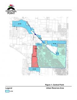
The Grant Road Concept Plan identifies how the city's future growth needs could be accommodated within the CP-5A/6A Urban Reserve Areas (URAs). As shown on the map to the right, these URAs are located west of the existing City Limits and Urban Growth Boundary (UGB) between Scenic Avenue (north extent) and Beall Lane (south extent).
Land Use Concept
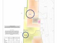
To comply with the Regional Plan Element, the Concept Plan, the Land Use Concept Plan provides a general land use distribution including 77% as Residential, 4% as Employment, and 19% as Parks and Open Space lands. Residential lands provide for a minimum gross density of 6.9 units per acre based on the minimum residential densities adopted in the Housing Element. Finally, the land use map proposes two (2) activity centers that serve as the focal point for future mixed use/pedestrian friendly areas envisioned to provide convenient and comfortable alternatives to automotive travel.
Transportation Concept
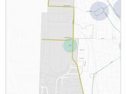
The Transportation Concept Plan identifies existing arterial and collector streets. The plan envisions future relocation of the current north/south Collector from the existing Grant Road alignment to the west to eliminate conflicts with Jackson Creek. The mixed-use/pedestrian friendly areas are envisioned to be designed as "transit-ready" corridors throughout the public street network, which will include sidewalks and bicycle lanes per the City's existing street standards.
Click any thumbnail image to view a slideshow


